I hiked a bit of the
Tuscacora Trail recently with a friend. I will call him "N" to protect the innocent . . or his reputation [ :) ]. The Tuscarora is an approximately 250 mile trail that connects to the Appalachian Trail on each end. The southern terminus is near Overall Run falls in the northern district of Shenandoah National Park. The northern terminus is near the Susquehanna River, just north of where the Appalachian Trail makes a major valley crossing of 15 miles or so. Between those points it runs roughly parallel to the AT, along ridges several dozen miles to the west. The trail was designed in the 1960s, during a time before the National Trails Act provided Federal oversight for protection of the AT corridor. At the time, there was concern that urban development would encroach upon the AT to the extent that an intact corridor would not be preserved - and the Tuscarora was envisioned as an alternate route.

We planned a roughly 50 mile section, starting from the northern terminus. N admitted to being in "less than ideal" shape, but we planned only moderately ambitious distances (mostly between 10 and 13 miles) along an elevation provide with minimal ups and downs with the exception of a 5-mile "roller coaster" section on day 3. It appeared manageable. From scouting ahead of time, I knew that water was scarce on the first ~20 miles of trail, so we cached some water near our intended campsite for the first night, left a car at the end point, and drove to the starting point of the hike. We started at Millers Gap on the
Darlington Trail, 1.5 miles further northeast along the ridge from the northern terminus of the TT. The
trailhead was a little obscure, but a friendly DNR officer happened by as we were putting the final touches on our packs and pointed us in the right direction. The Darlington Trail was well maintained, and in little time we found the intersection with the AT. As if to justify it's reputation as a "busy trail", I encountered three through-hikers just as I reached the intersection. We took a lunch break at the nearby shelter, then continued on our way. Turns out that the Tuscarora Trail is not nearly as well maintained as the Darlington (or the AT) in this area. Japanese Stiltgrass and other plants covered the trail much of the time, often to depths of a couple of feet. As we approached the first road crossing at route 34, the trail degenerated into a rutted stream channel, badly in need to re-contouring. We walked for 1/2 a mile along route 34 and then followed logging roads for several easy miles. Although this section was easy, we missed turns a couple of times - I
topped out a steep climb of a power line cut without noticing a right turn 20 yards before the top, and N missed a left from one old woods road onto another. The route became more rocky as the afternoon wore on. At 7:00pm we crossed an old woods road that indicated we were 3 miles from where we had stashed our water. With about 2 hours of daylight remaining, we figured we could get in before dark - but we were wrong. The route alternated between long grass through poorly-marked ridgetop and extremely rocky sections. Not as challenging as the climbs and descents of the White Mountains and western Maine, but probably the
rockiest "flat" section of trail I have ever seen. Around dark we reached the boundary of the
Reinmman Audubon Sanctuary. We continued for several hours through the darkness, proceeding by
spotting one blaze with our headlamps before clamoring over rocks to the blaze, then finding the next one. At midnight we finally reached the clearing at
Waggoners Gap where we had stashed our water. We had planned to hike another 0.8 miles to reach an official campsite, but given the conditions (it had also started raining, by the way), we
set up in a picnic area and called it a day.

Given the late night, we slept until mid-morning. It was still raining as we packed up, knowing that the next several miles were also reportedly
rocky and rugged. And indeed they were - it was mid-afternoon when we reached a landmark that indicated we had traveled a measly 4 miles. After a couple of easy miles, we traversed another rocky ridge, and it was nightfall by the time we reached the Tuscarora State Forest boundary. Though the plan had been to hike to the Wagon Wheel Shelter, we opted for a
trailside campsite in Wildcat Hollow, where a stream lulled us to sleep. Over dinner, we decided on a modified plan of action. N was having trouble with the rocks, and seemed unlikely to be up for the 17.5 miles we would need to do the next day in order to make it to the car. So we decided he would hike to nearby
Colonel Denning State Park and spend the night there. I would continued along our planned route, get the car the next day, and pick him up.

Day three dawned sunny and warm. I climbed out of Wildcat Hollow to
Flat Rock, where a broad view of the Cumberland Valley is accessible to anyone willing to hike 2.5 miles of relatively-steep trail from the state park. I saw ~10 people in the section of trail near the view; other than them, we had seen only one hiker in the previous days and I saw no others after that. There was a steep descent to the road near the state park, followed by a rather steep climb
back to the ridge. The next 8 miles were fairly easy, along an
old road with scattered rocks and downed trees on top of the ridge, with little variation in elevation. Next came the "roller coaster". This segment featured 3 very steep climbs followed by some even steeper descents. The route did not bother with switchbacks, and was so steep I feared I would tumble down the mountain in a few places. The last descent also featured large (3-4 foot diameter) rocks
in the middle of the steep trail. At last I reached Fowlers Hollow, where a shelter awaited. When I arrived at the shelter, I was puzzled at movement of a dark gray colored object in the corner - and discovered that a
porcupine was
inside the shelter, chewing on the wood. I decided to set up camp at a nearby stream instead of using the shelter. At least I arrived before dark.

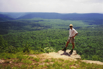
On the final day, I started with one more crazy-steep climb, reaching the edge of the
Hemlocks Natural Area on the top. This area is part of the Tuscarora State Forest, and features some short trails; it's accessible via
a dirt forest road. From there I followed the ridge top for 10 miles, alternating between rocky ridges and old roads. There was an excellent view (seen at right) at one of the high spots along the ridge. The southern end of the ridge featured another crazy-steep descent, after which I reached the road where we had parked a car 3 days earlier, and where I had ended my
40 miles in one day last Sept.
Here are
the rest of the photos.

 This summer I hiked 170 miles of the Pacific Crest Trail in Southern Oregon with my brother Mike. I am growing to really love hiking on this trail, with its mild weather, relatively easy grades (compared to the AT, anyway!), and beautiful scenery. This summer I started hiking at Green Springs Summit, near the town of Ashland, Oregon. Mike me up with my at highway 140 near Fish Lake, and we continued north together through the Sky Lakes Wilderness, Crater Lake National Park, past Mt. Thielson, and through the Diamond Peak Wilderness to arrive at Willamette Pass. I have documented details of the hike in my Trail journal. I have also created a Google Earth tour of the trip - which one can use with free Google Earth software to explore my trail journal from a geographic vantage. And here are the photos from the trip. In addition, here are a few of my other hiking links: John Muir Trail (PCT 2009) | Northern CA PCT (2010) | Appalachian
Trail (2004-2007) | My other trip
journals | Mike’s
journal for this trip.
This summer I hiked 170 miles of the Pacific Crest Trail in Southern Oregon with my brother Mike. I am growing to really love hiking on this trail, with its mild weather, relatively easy grades (compared to the AT, anyway!), and beautiful scenery. This summer I started hiking at Green Springs Summit, near the town of Ashland, Oregon. Mike me up with my at highway 140 near Fish Lake, and we continued north together through the Sky Lakes Wilderness, Crater Lake National Park, past Mt. Thielson, and through the Diamond Peak Wilderness to arrive at Willamette Pass. I have documented details of the hike in my Trail journal. I have also created a Google Earth tour of the trip - which one can use with free Google Earth software to explore my trail journal from a geographic vantage. And here are the photos from the trip. In addition, here are a few of my other hiking links: John Muir Trail (PCT 2009) | Northern CA PCT (2010) | Appalachian
Trail (2004-2007) | My other trip
journals | Mike’s
journal for this trip. I have now hiked 694 miles of the Pacific Crest Trail, which is just under 25% of the total mileage. I don't know if I will end up hiking the entire trail, but I would like to at least do some additional substantial sections. Just for fun, here's a list of the sections I have not hiked, listed in order of priority: