 I had a milestone birthday this year, so I decided I would conquer a bunch of hills instead of just going "over" one, and put in 40 miles of hiking in one day at the same time. Seemed like the appropriate number of miles! I have done several long hikes before, but they were mostly supported, organized events: the 62-mile "One Day Hike" from Georgetown to Harpers Ferry on the C&O Canal (twice); the ~40 mile "Hike Across Maryland" on the Appalachian Trail, and the 35.5 mile "End to End" hike on the Brandywine Trail in Delaware and Pennsylvania. But this hike would not be part of an organized event, and was supported only in the sense that my very accommodating wife offered to drop me off, meet me halfway, and pick me up at the end.
 I chose to do a section of the Tuscarora Trail, which is a route that runs parallel to the Appalachian Trail through the mid-Atlantic region. It was designed as an alternate route, back in the days (pre-1968) before the National Trails Act gave official protected status to the route of the AT. Now the Tuscarora provides a scenic, low-crowds ridgetop route from Shenandoah to north of Harrisburg, PA. The section I hiked for my birthday starts just north of the PA/MD state line, and ends near the town of Spring Run. I started my day with a 3:30 wake-up call in Greenbelt. The original plan had been to drive out to Hancock and stay in a hotel, but when our bus returning from a cross country meet in Delaware was delayed, we decided to scrap that plan. We arrived at the trailhead in time for a 6:00am start - before the sun rose at 6:45. I climbed over 1000' feet of sometimes-steep trail in the dark, and was greeted by first light as I crested the ridge. From there the route was mostly flat for the next 20 miles, according to the map. However, as it turned out, "flat" did not mean "easy". The first 12 miles of ridgetop hiking had seen little maintenance since spring, and was overgrown with several species of invasive plants, and at least two species bearing nasty prickers. There were also several long stretches of rocky, ridgetop route that made for slow going (see the photo above right). In many places the route was hard to follow, and although I knew I would not get lost because the trail stayed on a narrow ridge, it was still slow going for an agenda that involved hiking 3-4 miles per hour. But I did not panic, and enjoyed the clear blue sky and dry air - the first such day in many weeks - probably since my last Tuscarora Hike in May, actually.

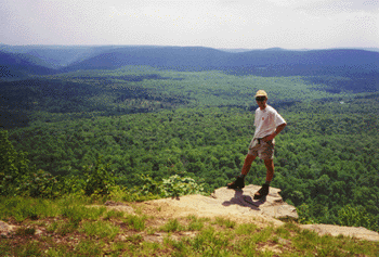
 After crossing PA route 16 at the 14 mile mark, the route got much easier. Vegetation had been cleared to the edge of the trail, and the route was well-marked. I began to make better time. Near the crossing of US 30 was a terrific view to the west, near a side used for launching hang-gliders. A bit further north, dark clouds appeared and it rained for a few minutes - but the rain was light and did not last long. Soon I came upon another terrific view, this one to the east and north (and pictured here). After descending steeply to Cowans Gap, I found Tatiana and the girls at the state park, hanging out on a blanket in the grass. Milepost 23.5, and it was already mid-afternoon. I hung around for a little less than an hour, then got on the trail again. Fortunately for me, much of the rest of the route - with the exception of three miles of narrow, rocky ridge, was along old woods roads which made for quick hiking. A few miles later I passed an intersection where the Great Eastern Trail splits off. This trail is a work-in-progress that is intended to be a continuous hiking trail from Tennessee to New York, by way of eastern Kentucky, West Virginia, and Pennsylvania. There are several alternate routes though the mid-Atlantic, and one follows the Tuscarora for a bit. Later I climbed to the rocky ridge where the trail crosses a mountain through which the Pennsylvania Turnpike passes in a tunnel. I could hear the roar of truck traffic for several miles. As I descended from this ridge, darkness was falling. I hiked the last couple of miles along lightly-traveled paved roads in the gathering darkness.
 Just for fun, here are some of my endurance "personal records", which I reflected on during this hike:
62 - most miles hiked in a day (C&O Canal, "One Day Hike")
28 - most miles hiked with a full backpack - on a day in Maine
27 - most miles run at one time (Boston and Marine Corps marathons - for the Marine Corp I jogged from the Pentagon metro to the start line because I was late - that was at least an extra 0.8)
75 - most miles biked in one stretch (I need to do a century sometime)
18 - most miles cross-country skiing (not sure about this one - there was an all-day loop that we used to do at Susqhehannock Lodge that I think was 18).
I have now hiked almost 150 miles on the Tuscarora Trail, which represents 58% of the entire route.
What do I want to try next? There are supported "endurance hike" events held on several other trails that I would consider. I would really like to do a one-day traverse of the Presidential Range in New Hampshire.
Here are the rest of my photos from the day.
No comments:
Post a Comment