
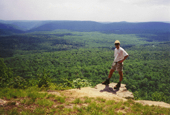
 This summer I hiked 170 miles of the Pacific Crest Trail in Southern Oregon with my brother Mike. I am growing to really love hiking on this trail, with its mild weather, relatively easy grades (compared to the AT, anyway!), and beautiful scenery. This summer I started hiking at Green Springs Summit, near the town of Ashland, Oregon. Mike me up with my at highway 140 near Fish Lake, and we continued north together through the Sky Lakes Wilderness, Crater Lake National Park, past Mt. Thielson, and through the Diamond Peak Wilderness to arrive at Willamette Pass. I have documented details of the hike in my Trail journal. I have also created a Google Earth tour of the trip - which one can use with free Google Earth software to explore my trail journal from a geographic vantage. And here are the photos from the trip. In addition, here are a few of my other hiking links: John Muir Trail (PCT 2009) | Northern CA PCT (2010) | Appalachian
Trail (2004-2007) | My other trip
journals | Mike’s
journal for this trip.
This summer I hiked 170 miles of the Pacific Crest Trail in Southern Oregon with my brother Mike. I am growing to really love hiking on this trail, with its mild weather, relatively easy grades (compared to the AT, anyway!), and beautiful scenery. This summer I started hiking at Green Springs Summit, near the town of Ashland, Oregon. Mike me up with my at highway 140 near Fish Lake, and we continued north together through the Sky Lakes Wilderness, Crater Lake National Park, past Mt. Thielson, and through the Diamond Peak Wilderness to arrive at Willamette Pass. I have documented details of the hike in my Trail journal. I have also created a Google Earth tour of the trip - which one can use with free Google Earth software to explore my trail journal from a geographic vantage. And here are the photos from the trip. In addition, here are a few of my other hiking links: John Muir Trail (PCT 2009) | Northern CA PCT (2010) | Appalachian
Trail (2004-2007) | My other trip
journals | Mike’s
journal for this trip. I have now hiked 694 miles of the Pacific Crest Trail, which is just under 25% of the total mileage. I don't know if I will end up hiking the entire trail, but I would like to at least do some additional substantial sections. Just for fun, here's a list of the sections I have not hiked, listed in order of priority:
1. Heading north from Tuolomne Meadows, at least as far as Donner Pass. This would cover the northern portion of the high Sierras
2. The northern ~750 miles, starting from where we left off this year in Willamette Pass. I expect that if/when I do this section it will be broken down into three separate hikes, each of which would be around 250 miles and 2 weeks. From Willamette to the Columbia River would be one logical segment.
3. At least one hike in the southern "desert" region of the trail, which covers 700 miles from the Mexico border to Kennedy Meadows, the beginning of the high Sierra.
4. At least one hike in the higher mountains of southern California, which span several distinct ranges near Los Angeles and are included in the 700 miles referred to in number 3. The lower elevation portions I could hike during a spring break, while the higher elevation segments reach above 8000 feet and could see snow that early in the year.
No comments:
Post a Comment