OK, time for list number 2. Most of my major dreams for backpacking trips involve the western US, now that I have hiked the entire AT. But there are a number of shorter trips in the Appalachians that I would like to do at some point as well. Many of these are weekend or 4-5 day affairs, or could be extended given the time.
I would actually consider hiking the entire AT at once sometime in the future. If I ever do it, I would probably start around the first of May and aim to finish by the end of August, maybe mid-September. This would prevent hiking in iffy weather and late snows in the south and would maximize appreciation of the rhododendrons in May-June. It would also allow me to finish before early wintery weather is likely in Maine. It would be a fairly ambitious pace - roughly 500 miles per month, 125 per week.
I have also included some favorite sections of the A.T. that I would like to repeat with friends or family as shorter trips. Once again, I am not ranking them in order.
1. Laurel Highlands Trail. This is a ~70 mile route through the Laurel Highlands region in southwestern PA. It's one of our favorite places - we were camping in Ohiopyle when we got engaged, and we have skied and hiked in the area a few other times. This route has regular shelters, and I envision it would be good for a first long trip for Calista . . so a few years down the road, and only if she takes to backpacking!
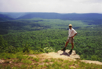
2. Repeat Presidential range on the AT. The ~30 miles of trail between Crawford Notch and Pinkham Notch in New Hampshire's White Mountains include over 15 continuous miles above treeline. It's one of the most spectacular and memorable sections of the 2175-mile trail. I am interested in hiking the Presidentials as an extreme day hike (one can start north of Madison Hut and make it around 25 miles, I think). For backpacking, given the time, I would add the next section south to Franconia Notch, which would include Mount Lincoln and Lafayette; and possibly the Carter-Wildcat range to the north as well. I have also been thinking about hiking part of all of this route from hut-to-hut, staying at the high-elevation enclosed primitive lodges that are maintained by the AMC. Accommodations are a bit pricey, but would make a memorable family trip.
3. Green Ridge State Forest/C&O loop (MD). This is a a~40-45 mile loop that could be done in 3 days and is close to home - the trailhead is less than 2 hours away. Half of the route is along a traditional hiking trail in MD state forest land, and the rest follows the C&O Canal towpath along the Potomac River through rugged and undeveloped mountain terrain. The canal route includes a trip through the Paw Paw tunnel.
4. Foothills Trail (SC). This route follows a route in the high-elevation portion of South Carolina, near the NC border. It's a good 5-7 day route (76 miles), and gets good reviews for waterfalls and solitude. The trail passes through Table Rock State Park, which is said to offer outstanding views.
5. section of the Mountains-to-Sea Trail (NC). This trail is a work-in-progress that will eventually span 1000 miles west-to-east in North Carolina, from Clingmans Dome in the Smokies to the ocean. I think it would be fun to do a week-long section on the mountainous western end of the trail.
6. Florida Trail through Ocala or Appalachicola. The Florida National Scenic Trail starts in Big Cypress National Preserve, just north of the Everglades, and winds it's way through forest remnants along the middle of the state, then turns west to trail the panhandle region. Including alternate and side routes there are around 1000 miles of trail in the system. Some hikers start in Big Cypress (or even in Key West, hiking initially along US route 1) and make their way through connecting routes in Alabama to the AT, then north to Maine. I am not that ambitious, but I would like to do the ~70 mile section in Ocala National Forest, which lies just north of Orlando. This segment has some wilderness character and would be a fun March (spring break) excursion. Another option would be to hike in Appalachacola National Forest, in the panhandle region.
7. Repeat Roan Mnt to I-81 (AT). One of my favorite sections of the AT included the areas around Roan Mountain, the Grayson Highlands, and the Smokies. Given enough time, I would hike from Fontana Dam through the Smokies, over Roan and Rogers again. A one-week trip could start (or end) at Roan Mnt and hike north to Mt. Rogers and beyond. A good end point would be the Settlers Museum, just a few miles from I-81.
8. Repeat Long Mnt. Wayside to Rockfish Gap (AT). We day-hiked this segment over a couple of days, and it included some beautiful views and grassy ridges. I would love to explore them again, especially in May-June or in the fall. A good opportunity for a long weekend or a 5-day trip.
9. Allegheny Trail (WV). This 330-mile trail runs north-south through West Virginia, starting near Pearisburg on the AT and ending north of Canaan Valley - one of our favorite places. It's much less-used than the AT or other eastern trails, and would provide good opportunity for solitude. At this point I am interested in any length trip along this trail, whether a weekend or a full week. A portion of this trail is part of the route for the Great Eastern Trail, a long-distance route that parallels the AT further west. It includes the Sheltowee Trace in Kentucky, the Cumberland Trail in Tennessee, the Pinhoti Trail in Alabama, and the Tuscarora Trail in VA/PA, and in total extends from Alabama to NY.
10. Northville-Lake Placid trail. This would be another good week-long excursion, running north-south through the Adirondacks. We have skied a portion of it in the south. There are shelters along the route. It would also be interesting to connect this route to the High Peaks region and summit one or two of the high peaks there at the end of the trip.
Also worth mentioning:
Tuscarora Trail - this ~250 mile trail was envisioned in the 1960's, before the National Trails System act provided federal protection for the AT corridor. Hikers were concerned that the AT route through northern VA and MD would become over-run with development, so they designed this alternate route as a "back-up". It now provides an interesting alternate route, starting near Overall Run Falls in northern Shenandoah and re-joining the AT near Harrisburg, PA. The Potomac Appalachian Trail Club is working in building shelters along the route, with a goal of achieving similar coverage to the AT - shelters every 10 miles or so along the entire route. I have hiked ~60 miles of this trail, mostly at the southern end. It would not be too difficult to use day-hikes and weekend trips to complete the trail without a long-distance backpacking trip.
Pennsylvania trails - there are many little-explored routes in north-central PA, some of which I hiked with the Wilmington Trail Club when I lived in Delaware. There is much more to explore, along the Mid-State Trail, Susqhehannock Trail, and a long section of the 3000+ mile North Country Trail.
Southern Appalachians - with thousands of acres of National Forest land, the southern Appalachian region is covered with trails, for myriad hiking options. I could probably do a long hike here every summer and never leave the region. Other designated trails include the Bartram Trail and the Benton McKaye trail.
Other AT sections - some other favorite portions of the AT that I would like to re-visit include the New Jersey section; Nantahala National Forest (NC); Green Mountains (Vermont - also part of the Long Trail, on my other top 10 list); and most of Maine (given how rugged it is, I can't believe I am including this section - but it truly was beautiful).
Sunday, May 15, 2011
Wednesday, May 11, 2011
Top ten "wish" list . . . US backpacking trips
I like to make lists and to dream about travels . . and since last summer I have been considering where I would like to backpack in the future. I have backpacked quite extensively since graduating from college, although the pace has slowed a bit in the past three years. I have hiked the entire Appalachian Trail, and have done two long sections on the Pacific Crest Trail. When I did my first PCT section I was thinking of hiking the entire trail over the course of several years, but now I am not sure - there are lots of other areas to explore, and I am not keen on doing the southern 700 miles in the summer (too hot and dry) or spring break (potential for snow in the higher sections).
So anyway, below is a list of my top 10 backpacking "dream trips". They are not in any particular order.
1. PCT – Crater Lake section. In the ideal world, I would like to hike all of Oregon, and include trekking past Mt. Hood, Jefferson, and the other spectacular Cascade volcanoes. But I figure this would be a good start - Mike and I are tentatively planning to do this section (150-200 miles - depending on how much time we have?) through the Sky Lakes wilderness and Crater Lake in summer 2012.
4. CDT Weminuche wilderness. This is a remote, high-elevation section of the Continental Divide Trail in southwestern Colorado. I would also like to do several representative sections along this National Scenic Trail, and the Weminuche seems like a highlight, with many miles above treeline.
So anyway, below is a list of my top 10 backpacking "dream trips". They are not in any particular order.
1. PCT – Crater Lake section. In the ideal world, I would like to hike all of Oregon, and include trekking past Mt. Hood, Jefferson, and the other spectacular Cascade volcanoes. But I figure this would be a good start - Mike and I are tentatively planning to do this section (150-200 miles - depending on how much time we have?) through the Sky Lakes wilderness and Crater Lake in summer 2012.
2. PCT – Tuolomne Meadows to Sierra City. In 2009 I hiked the entire John Muir Trail, which is also the route of the PCT through the high Sierra. This section would continue north from there, through Yosemite and above Lake Tahoe. I am not sure if Sierra City would be the ultimate endpoint, but it seems a logical goal given enough time. It would be great to go all the way to Lassen . . . I think the minimum endpoint goal would be Donner Pass, where I-80 crosses the mountains.
4. CDT Weminuche wilderness. This is a remote, high-elevation section of the Continental Divide Trail in southwestern Colorado. I would also like to do several representative sections along this National Scenic Trail, and the Weminuche seems like a highlight, with many miles above treeline.
5. Wonderland Trail. This trail encircles Mount Rainier in Washington. Tatiana have been talking about doing it for several years now . . maybe a 10th anniversary trip? That would be 2013 - not too far off now! It's roughly 90 miles, so it can be done in about a week, perhaps a bit less, depending on how much we are willing to take on . . I would be aiming to do it without a re-supply.
6. CDT – Wind River Range to Yellowstone. This rugged alpine area in Wyoming regularly gets rave reviews. I am not sure how long this segment is because I have not done much research on it, but the notion of a trail starting in this remote paradise, continuing through the Tetons, and into the wolf and grizzly abode of Yellowstone sounds very attractive - and wild.
7. CDT – Bob Marshall wilderness and Glacier. The Bob Marshall Wilderness is the largest wilderness area in the lower 48 states, and is adjacent to Glacier National Park. A trip through the entire region along the CDT, perhaps ending at Waterton Lakes in Canada, would be spectacular. I have already hiked part of the route on a 5-day loop in Glacier, back in 2002.
8. Colorado Trail. This trail winds through the Rocky Mountains in Colorado, with much terrain at very high elevation. A significant portion of it is concurrent with the CDT.
9. Long Trail. This is my first entry for an eastern US trail. I plan to create a second list of east-coast trips, since there are many shorter/less-intense trips I would like to do out here too. I have already hiked ~30% of the Long Trail, in southern Vermont where it's the same as the AT. But it would be fun to hike the entire route, north-south through the Green Mountains from Canada to Massachusetts (or, more likely, the other direction). There are some great alpine zones on the higher peaks in the northern part of Vermont. This would be a good 2-3 week trip, depending on pace.
10. International AT. This route was off my radar until recently, when I watched a promotional video for a new section of the IAT in Newfoundland - which looks beautiful and wild. The rest of the more-established route heads north from Katahdin in Maine and winds through New Brunswick and Quebec.
Runners-up:
Here are a few other places where I would like to hike - with a less well-developed notion of a route or time commitment:
* Ruby Mountains, Nevada - this area in eastern Nevada is said to have the most alpine character of any of the Great Basin ranges. A medium length (30ish miles) linear trail runs along the range.
* Central Idaho - hiking in the Frank Church-River of No Return wilderness just sounds really wild. And I frequently come across beautiful photos of this area. There are reportedly over 2000 miles of trail, so finding a route should not be a problem . . .
* Olympic Peninsula - Washington - photos of Hurricane Ridge, in the center of the peninsula, suggest a very scenic location.
* Canadian Rockies - another scenic area with lots of trail possibilities, stretching from Banff through Jasper to Mount Robson.
Next up . . . a list of top 10 Eastern trips! :)
Wednesday, May 4, 2011
One Day Hike
 We participated last weekend in the One Day Hike. We walked the C&O Canal towpath from Georgetown to Harpers Ferry, a distance of 100 Kilometers (62 miles). The hike starts at 3:00am at Thompsons Boathouse in Georgetown, at the end (or beginning, depending on perspective) of the canal - and also the mouth of Rock Creek, where it empties into the Potomac. I finished at 8:30, and Tatiana glided in just before 10:00pm.
The weather was perfect for the hike, and we enjoyed the scenic route in spite of some blister-y feet. The towpath parallels the canal - which was built starting in the 1830s and active less than 100 years - for the entire route. In places, the canal is full of water; in other sections, the water has drained out. In many places the route also featured a good view of the Potomac, which was rushing along at high volume after recent  rains. I saw lots of other trail users, notably participants in two bike and/or running relays that were headed the other direction.
rains. I saw lots of other trail users, notably participants in two bike and/or running relays that were headed the other direction.I don't think we will be doing this hike again. It's fun, but the logistics (Calista stayed with some friends of ours, who also picked us up) and dealing with the blisters make it a challenge. But I would not rule out doing other long hikes. In the past we have done the Wilmington Trail Club's "End to End" on the Brandywine Trail (~36 miles of forest, field, and old roads in northern Delaware and Chester County PA) and the Hike Across Maryland (~41 miles of the Appalachian Trail from PenMar, on the PA-MD line, to Harpers Ferry. There are several similar organzied events, including one on the Rachel Carson Trail in western PA. One challenge I would like to take on is to hike the entire Presidential Range in the White Mountains in one day.
Here are some other photos that I took on the hike. And some more on the hike's official Facebook page.
Subscribe to:
Posts (Atom)