I have a limited time while on a re-supply to give a quick update on my trip! I am at Vermillion Valley Resort, which lies across a lake from the trail. I arrived here by ferry this afternoon. The hike has been awesome so far - views are almost continuous, and weather is excellent for hiking. I should have some outstanding photos when I get back, so I am looking forward to sharing them.
If all goes well, I will leave here tomorrow morning, then hike for 5 more days. I should hike through Tuolomne Meadows on Saturday and then arrive in Yosemite Valley on Sunday.
Tuesday, July 28, 2009
Sunday, July 5, 2009
Anniversary
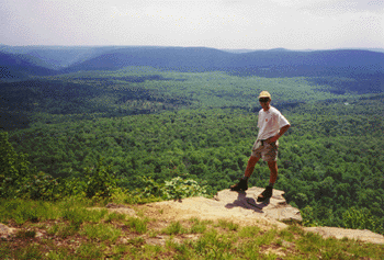
 As of today, we have been married for 6 years! Hard to believe. To celebrate, we did a short backpacking trip in western MD. It was our first trip in two years, unless you count Cumberland Island, which consisted of no more than 1/2 mile carrying a pack. We hiked the Savage Loop, which is approximately 25 miles on (mostly) state forest land in Garrett County - near Deep Creek Lake. A map of the area can be seen here. The route was varied and quite unusual. We started with a couple of miles of traditional hiking trail through New Germany State Park - an area that has groomed ski trails in the winter. The next segment was an old CCC road, now open to ORVs and high clearance vehicles. There were numerous campsites scattered along the route, which follows a stream through deep forest. The road crosses the creek multiple times, most of them without bridges. We had to "ford" the crossings, since they are clear of rocks to allow vehicles to pass. We ended up walking in sandals for several miles.
 The next segment consisted of 5 miles along a little-used, scenic paved road. The road follows a larger stream through state forest land and past a few houses. After passing through a primative campground at Big Run State Park, we merged onto the Monroe Run trail. This trail also features multiple stream crossings, most of which were fairly easy to traverse by rock-hopping. We counted 24 crossings in all. We found a campsite partway up this trail. The next day we climbed the rest of the way up the stream and then steeply to the top of Meadow Mountain. The rest of the route was a wide, grassy trail (pictured above) which is used by snowmobiles in the winter but open only to foot and bike traffic the rest of the year. There were several views towards long, forested mountain ridges that are typical of the central appalachians. There are some more pictures posted here.
Subscribe to:
Posts (Atom)